GroundLogs boring log software is located in the cloud and accessed through your web browser. You do not need to install any licenses or upgrades to use the software. You can use the software in a variety of ways, depending on your particular needs:
- Field logging software, integrated with your current boring log software – use the software to collect your field data electronically, receive a digital data file, and use the data file to complete the boring logs using your current software.
- Integrated field logging/boring log software (GroundLogs) solution – use the software to collect your field data electronically and create boring logs in one of the GroundLogs standard PDF templates, or in one of our gINT® or LogPlot® templates.
- Boring log software – enter your paper field notes and create boring logs in one of the GroundLogs standard PDF templates, or in one of our gINT® or LogPlot® templates.
The software is housed in a secure web portal which you log into. Once you have entered data into the software, you can receive PDF logs and/or digital data files, or have your data drafted into gINT® or LogPlot® logs. To start using GroundLogs software, all you need to do is register today.
GroundLogs software versions and features
There are two versions of GroundLogs software currently available:
- Basic (Free) – Basic logging and single well construction functionality for simple site investigations; and
- Pro (Paid) – Advanced logging and multiple well construction functionality for more complex site investigations or projects involving rock or frozen soil.
Both versions contain the industry-unique user interface which “looks like paper, but does more.” A list of features is provided at the bottom of this page.
Price out our online boring log software versions, and learn about our payment options, at Software pricing.
Benefits of web-based boring log software
Web-based boring log software offers the following advantages over traditional licensed boring log software:
- You don’t have to pay license, maintenance, or upgrade fees;
- You can access the software and work your logs from anywhere with an internet connection (office, home, or road);
- Your colleagues can view your logs in progress real-time, regardless of their office location;
- You only have to learn one user interface for both field logging and office data entry; and
- You and your colleagues will be able to enter data in a consistent format each time when using the software.
What makes GroundLogs software different?
GroundLogs software is different because it was designed by a field geologist with experience in implementing field logging software for consulting firms. We designed that practical experience into GroundLogs software and into how we offer the software to the geoconsulting industry. We believe the software has to meet the following criteria, especially if it is to be successfully implemented for field logging:
- The user interface should mimic a paper field logging form to facilitate the transition from paper to electronic logging;
- The software should be intuitive to learn and use for anyone that has logged soil borings on paper;
- Field users should be able to see field data in a log format without having to launch other software;
- The software should be based on industry standards and facilitate adherence to those standards;
- The software should capture basic information required for typical geotechnical/enviromental site investigations;
- Data entry should be as efficient as possible, to allow field personnel to keep up with the drillers; and
- The software should be offered in a way that allows consultants to try it out with minimal financial risk.
Due to its web-based platform and origins in field logging experience, GroundLogs software works for both field logging and office data entry. It is intuitive, thus requiring very little training and allowing report-quality logs to be created without specialized skills. That is why we say: “If you can log a soil boring on paper, you can use GroundLogs software!”
GroundLogs software features
The below sections provide a description and image of each of the features of GroundLogs software and whether or not that feature is included in the Basic or Pro versions. For international users, GroundLogs software is also available in metric units.
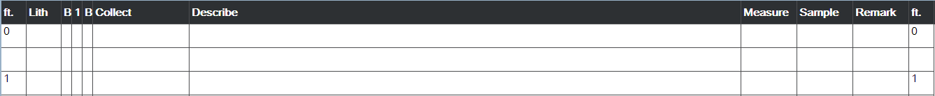
The GroundLogs data entry log table is an industry-unique user interface where you initiate data entry and see the data you have entered in a log form format. You use this same interface for field logging on tablet computers and data entry on desktop computers. You can adjust the scale interval of the log table based on the boring depth and sampling intervals, or enter data into the table one row at a time, based on your data intervals.
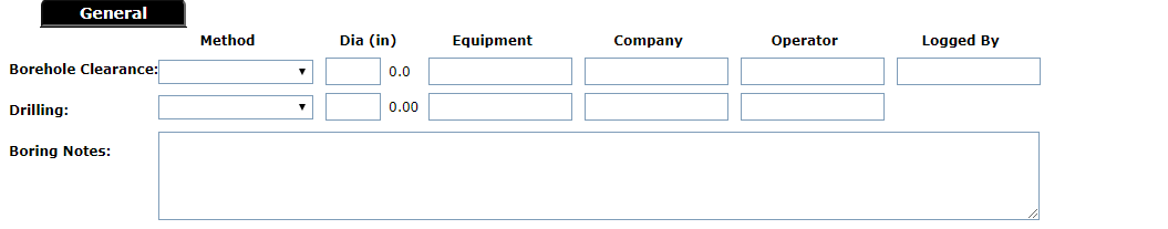
General data refers to information about borehole pre-clearance and drilling methods, diameters, subcontractors, personnel, as well as general notes related to the boring.
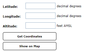
Location data refers to boring coordinates and ground surface elevation.
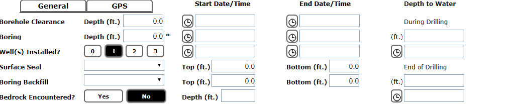
Boring data refers to borehole clearance, drilling, and well installation start and end dates and times; depths to water during and after drilling; and borehole completion (number of wells installed and backfill materials).
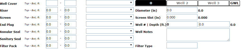
Well data refers to well construction components and their depths, and general notes related to the well(s). With the Basic version, you can create one well per boring, and with the Pro version, you can create up to three wells per boring (nested wells).
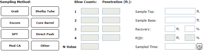
Collection data refers to sample collection methods and intervals, blow counts and rock quality designation, and recoveries.
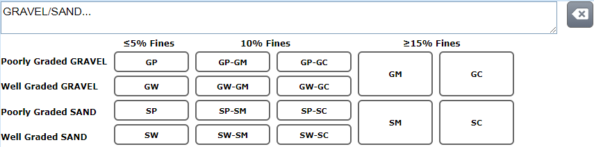
Soil description data (USCS) refers to soil descriptions based on the Unified Soil Classification System. In addition to the USCS group name and symbol, you can describe percentages of gravel, sand, silt, and clay, gravel and sand grain sizes, grading/plasticity, density/consistency, color and moisture for the soil.
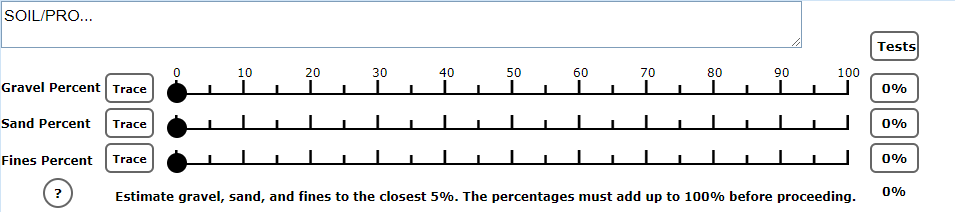
Soil description data (ASTM) refers to soil descriptions based on the ASTM Visual-Manual Procedure (D2488). From Section 12.3.1 of the Standard: “The percentages shall be estimated to the closest 5 %. The percentages of gravel, sand, and fines must add up to 100 %." Once you enter the percentages, the soil group name and symbol is calculated. You can also record field tests for fine-grained soil, and describe gravel and sand grain sizes and angularity, density/consistency, color (including Munsell), and moisture for the soil.
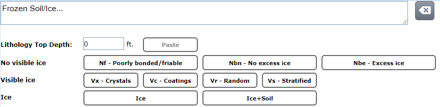
Frozen soil description data refers to frozen soil descriptions based on the ASTM Description and Classification of Frozen Soils (D4083). After classifying the frozen soil, you can describe the relative percentage, hardness, structure, and color of the ice.
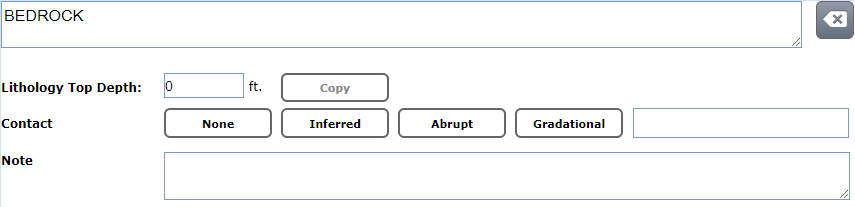
Rock description (text) refers to rock descriptions entered as text entries.
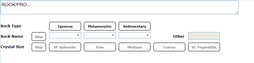
Rock description (ISRM BoR) refers to rock descriptions entered according to the International Society of Rock Mechanics (ISRM) (1981) and the Bureau of Reclamation (2001) standards. In addition to crystal/grain size, you can describe bedding, weathering, hardness, fracturing, and other properties of the rock.
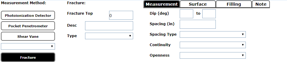
Rock fracture data refers to the properties of fractures in rock.
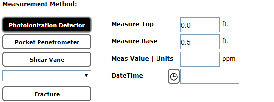
Field measurements refers to field test methods, depth intervals, and results with units.
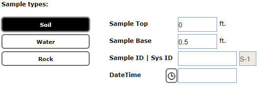
Lab sample data refers to soil, water and rock samples collected for laboratory analysis, and their depth intervals.
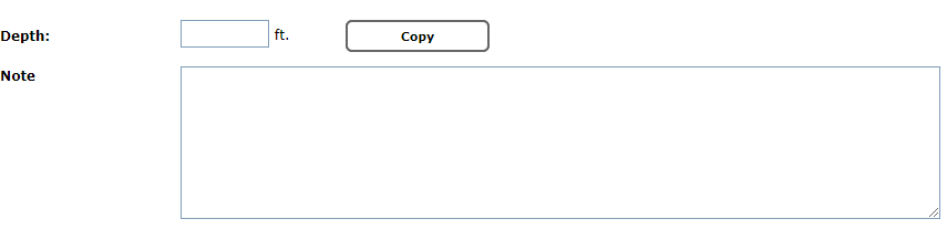
Remarks refers to drilling-related or other remarks.
If you are ready to start using GroundLogs software to create boring and well logs, simply register today. If you have any questions about the specific features in GroundLogs software, please contact us.
Data entry log form
General data
Location data
Boring data
Well data
Collection data
Soil description data (Unified Soil Classification System; Basic version)
Soil description data (ASTM Visual-Manual Procedure; Pro version)
Frozen soil description data (Pro version)
Rock description data (text entry; Basic version)
Rock description data (International Society of Rock Mechanics/Bureau of Reclammation standards; Pro version)
Rock fracture data (Pro version)
Field measurements
Lab sample data
Remarks